29
riżultati fi ħdan
Suġġett
 Manuscript map
Manuscript map
Map created in handwriting, for handdrawn maps use Q122395769

Oriented with NNE to the top.; Relief shown by hachures.
Scale 1:2.500.; Scale bar in the bottom right corner, unit: rod (Rheinische Ruthe).; Oriented with E to the top.; …
Scale [approximately 1:7.700].; Oriented with SSE to the top.; In the lower right corner in rocaille cartouche an explanation of 73 buildings marked with numbers and letters on the plan, a linear scale in steps below.; …
Scale [approximately 1:25.000].; Oriented with NNW to the top.; Title in an oval cartouche in the bottom right corner, the scale bar on the left (unit: Ruthen Rheinl.).; …
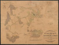
Relief shown by hachures.; Decorative border around the map.; Handwritten map showing the camp near Nollendorf (Krásný Les) - region in the Ore Mountains with the villages of Telnitz (Telnice), Zukmantel, Kinnitz, Böhmisch Kahn (Velké Chvojno) and Konigsw…
Explanations of objects marked on the map by letters include on the upper right.; Note on the right bottom under the frame: Postel fecit 1788 d. 23. Maij.; In the top right corner: No 5?.
Plan of the Battle of Lutynia (5th December 1757) during the Seven Years' War (Third Silesian War).
Scale indeterminable.; Showing the deployment of troops before the Battle of Rossbach on 5th November 1757 between the Prussian army and the joined Franco-Austrian forces.
Scale [approximately 1:1.000.000].; Title above the map.; Legend under the bottom frame.; …
Oriented with NNW to the top.; Decorative title cartouche above the map.; Plan of the duel that took place on 27th June 1784 near the village of Olszyniec (Wellersdorf), between Żary and Żagań.; …
Kaart van de Leidse Vaart, met de namen van de eigenaars van de aanliggende percelen
Manuscriptkaart van de vestingwerken van Zutphen met linksboven de titel: 'Plan de Zutphen' en daaronder de legenda in het Frans. De schaalverdeling staat onder de tekst. Het ontwerp voor dit fort werd circa 1785 gemaakt. Op deze kaart zijn de ves…
Scale [approximately 1:60.000].; Title in French in the lower right corner.; Relief shown by hachures.; …
Scale [approximately 1:5.000].; Oriented with NE to the top.; Title in an oval cartouche at the top in the middle, under the cartouche the scale bar (unit: Ruthe).; …
Oriented with NE to the top.; Relief shown by hachures.; Title in a rectangular frame in the upper right corner.; …
Oriented with NNW to the top.; A handwritten plan of Stara Kraśnica, additional table below the plan; the note below: Schoenau, im Maerz 1863.; Map backed with linen.
Scale [approximately 1:5.000.000].; Contour map showing the Danube river from its source to the region of the city of Baja (Hungary).; Includes cities (described only with the first letter).
Scale indeterminable.; Oriented with NNW to the top.; A handwritten plan showing the silver and lead ore mines from the region of Lutynia and Lądek-Zdrój.
Scale not given.; Title cartouche on upper right.; Explanations of objects marked on the map by letters include on the bottom left.; …
Scale 1:10.000.; Oriented with SW to the top.; The areas covered by the flood in July 1903 were marked.; …
Scale [approximately 1:2.500], scale bar below the title (unit: Rheinische Ruthe).; Oriented with NE to the top.; Title on the right margin.; …
Scale [approximately 1:40.000].; In the upper right corner title cartouche with scale bar in steps and rods (units: Schritt, Ruthe).; Oriented with S to the top.; …
Scale [approximately 1:2.900].; Oriented with SSE to the top.; Title in the upper right corner, scale bar below the plan (unit: Schritt).; …
Scale 1:2.500.; Scale bar (unit: meters).; Title devised by cataloger.; …