25 418
resultat inom
Ämne
 Flygfotografering
Flygfotografering
Fotografering av marken från flygplan eller andra luftfarkoster

Flygfotografi över Viborg.
Aerial photograph of the hockey pitch at Oberhausener Tennis- und Hockey- Club in Oberhausen, Germany. May 2010.
Portmarnock Raceway is a track in north county Dublin for harness racing. Harness racing is a form of horse racing in which horses race at a specific gait, usually pulling a two-wheeled cart called a sulky. Portmarnock Raceway originally opened in 1969. …
Aerial photograph of London 2012 Olympic venues. Taken in May 2010, the venues are still under construction. Pictured are the London Olympic Stadium, the London Aquatics Centre, and the buildings which would be the Athlete's village during the London …
Kinsealy Grange opened in 2007 and is a golf driving range for training and practice in north county Dublin.
Trip to China, aerial view, temple of heaven in Beijing
Aerial photograph of Rotterdam Europort. Photograph taken in July 2019.
Aerial photograph of quarry near Bucelas, outside of Lisbon, Portugal. The quarry is operated by Bucelbritas, to extract Lioz, a rare type of limestone that occurs in the Lisbon region.
The M7 Portlaoise–Castletown/M8 Portlaoise–Cullahill Motorway scheme through County Laois will comprise 41 km of motorway and 11 km of link roads (Illus. 1). It will commence from the existing Portlaoise Bypass and tie in with the N7 Castletown–Nena…
Content description: Iväylä in Herttoniemi.; colored
Content description: Taka-Töölö, Olympic Stadium.; colored
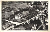
Karlskoga,disponentbostaden Bofors från flygfoto
colored
Flygfoto över Mullhyttemo. Bilden tagen vykort.
Technical sheet for shooting aerial photographs, based on shadows
Content description: Konalantie. A bevel aerial photograph of a small plane from the southeast direction of Konalankuja to the east facing Klahisö road. North end of Konalantie, left Hilapellontie. In the middle of Vihdintie. In the background, the Male e…
Content description: Roihumäki, Tuhkimontie 10 and 12, and Roihumounentie 5, 7 and 10. In the background, Herttoniemi industrial area. The shooting direction is west-northwest.; black and white
Content description: The fishing harbour and Sörnäinen seen from the east, Kulosaari Bridge on the left, the Kalasatama metro and the Verkkonen Island shore on the right.; colored
colored
Content description: Aerial view of Vallisaari Island. In the foreground, the office building of the military department on the island, built in the early 1900s, can be seen on the left. A school building completed in 1958 can be seen on the right side. T…
Content description: Aerial view over Etu-Töölö. Photograph taken from South Lunch. In the foreground appears Hietakanas with walkways and fields. Along its edge runs Väinämöisenkatu street. In the middle between the houses appears Caloniuksenkatu, which …
Content description: A bevel aerial photograph of a small plane from the direction of Lava salons (front) to the southwest. In the middle of the Reiherintien apartment buildings. In the background, on the left, the oil harbour of Lava with its oil tanks.;…